(PL2 - LOCAL PEDESTRIAN ROUTE 2)
The Trail of Abadia runs through the rural village of Santa Maria de Bouro constituting a local path. It has a length of 9.8 km, with an average time of 3 hours long with a moderate degree of difficulty. The maximum altimetry height is 550 m and is reached in São Miguel do Anjo, being the lowest elevation of 150 m corresponding to the beginning of the trail.
This trail translated into a rural route beginning at the Monastery of Santa Maria de Bouro, with the possibility of visiting the convent. Therefrom, the route goes alongside a series of old mills along the one taken from water to meet a staircase that will lead to Ribeira da Abadia. The climb to the viewpoint of St. Miguel do Anjo is done through sand road surrounded by large plant density.
From the viewing platform of "São Miguel o Anjo” you can admire the surrounding area of this trail. One of the points of interest of this trail is the Sanctuary of Nossa Senhora da Abadia, a unique and isolated place surrounded by mountains, being the 1st elevation of the Serra do Geres. Towards the final part of the trail we went back to the Monastery of Santa Maria de Bouro through the Calçada Rebentaço. Going downhill during the route, it is possible to admire a group of chapels aligned in the form of the Stations of the Cross.
Location: Amares
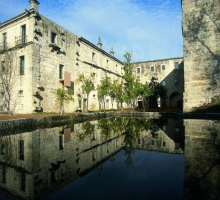